

Following its successes with reconnaissance and armed unmanned platforms Baykar, the Turkish leader in the UAV field and one of the world key payer launched at Saha Expo exhibited in public for the first time its three latest developments, all three belonging to the loitering munitions category
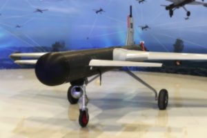
The K2 kamikaze UAV was visible in real size in the outdoor display. With a 10 metres wingspan, the K2 is 5.1 metres long and can carry a payload up to 200 kg. The airframe features a canard configuration and does not feature any vertical aerodynamic surface at the rear, but rather a short one under the fuselage, around the centre of it. Rudders are fitted to winglets that we find at the tip of the main wings. Propulsion is provided by an internal combustion engine (ICE) fitted at the rear of the fuselage generating 100 hp, which operates a three-blade pushing propeller. Cruise speed is 70 knots while maximum speed is 110 knots. The K2 can fly for over 13 hours and has an operational range of more than 2,000 km; its operational altitude is 8,000 feet while service ceiling is 10,000 feet. Line-of-sight (LOS) communications range is over 100 km, sufficient if the K2 is used for extensive loitering missions; should the UAV fly at great distances a beyond-line-of-sight communications (BLOS) channel can be installed. It can also be fitted with the sae datalink used on top class UAVs from Baykar. The K2 can take-off in full auto mode and carries two Azak E5 munitions, jointly developed by Baykar and MKE.
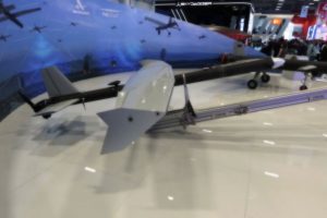
The Mizrak, spear in English, is a next generation intelligent loitering munition which airframe is made of a 3.6 metres long cylindrical fuselage on which are fixed two canard wings, the main a 4.0 metres span wing with winglets, while the rear empennage is limited to the vertical rudder. With a maximum take-off mass of 200 kg, the Mizrak can carry a 40 kg payload. Powered by an ICE operating a two-blade propeller, cruise speed being 80 knots while maximum speed is 20 knots higher. Service ceiling is 10,000 feet, however operational ceiling is much lower, 4,000 feet. The Mizrak is fitted with a forward tricycle landing gear, but alternatively it can be launched from a ramp using a rocket booster, freeing the system from the need of a runway. Once airborne it can fly for over seven hours, with an operational range in excess of 1,000 km. A gimballed electro-optic sensor suite is fitted in front of the forward landing gear. Maximum payload capacity is 40 kg; two different options being available, using the full load for warhead, or fitting a 20 kg warhead together with a radar seeker to be used in the final attack phase. Usually fitted with a LOS communication system, it can be upgraded with a BLOS system and can be equipped with the datalink.
Last but not least comes the mosquito, Sivrisinek in Turkish language. Looking at the airframe it is clear that Baykar was looking for a very affordable solution, the cylindrical fuselage being 3.8 metres long, on which a 3.2 metres span wing is fixed with cable ties, the same being true for the tailplane and rudder. Also powered by an ICE operating a two-blade propeller, it is provided in two different configurations, UM and UMX, the main difference consisting in the AI-assisted electro-optic camera fitted to the UMX. This adds 2 kg to the 76 kg maximum take-off mass of the Sivrisinek UM, while the increased drag brings the flight endurance from over 9 hours down to over 8 hours, the range being also reduced from 1,000 to 900 km, operational altitude and service ceiling being the same of the Mizrak. The Sivrisinek is catapult-launched and its payload capacity is 20 kg, which is fully used to carry a warhead.
All the above described systems are fitted with advanced autonomous navigation, artificial intelligence-based target recognition algorithms, and integrated mission planning software.
Equipped with full autonomy powered by artificial intelligence, the smart loitering munitions Spear and Mosquito can find and engage targets with high precision even in the most challenging terrains, thanks to their AI-powered visual positioning capability independent of GNSS.
Photos by P. Valpolini