

Abstract
Uncrewed aircraft did not fail Nepal’s 2026 flood response; the airspace above the disaster did. Cheap heavy-lift and thermal drones have become decisive in the first hours of a catastrophe, but they arrive faster than any structure to command them, and the resulting saturation slows the response it was meant to accelerate. The remedy is not new technology but an old staff discipline: an air coordination element stood up on day one, with authority to assign airspace rather than merely observe it.
Introduction
Seven bodies made the trip from Devighat-3 to Devighat-5 slung beneath a cargo drone. The two are neighboring riverside wards of Bidur, the district town in Nuwakot, beside the Devighat hydropower station on the Trishuli. The ground between them was gone. No road, no footing, nothing a recovery team could cross on foot. A delivery drone rated to lift 85 kilograms, built for rice and medical supplies, was doing the only work available.
That is what uncrewed aircraft did for Nepal, and it is not the problem. The problem is the sky they flew in. When a disaster draws international attention, the aircraft arrive faster than anyone’s ability to coordinate them, and the profession has not solved that. The failure is one of command, not of engineering.
On the morning of August 26, 2026, a wall of water entered Nepal through the Bhote Koshi river and ran down the Trishuli corridor, striking settlements across Rasuwa, Nuwakot, and Dhading districts and across the border into Tibet. Nepali authorities have not settled what caused it. The assessment was that it was a glacial lake outburst flood or another upstream hydrological event, and the investigation remained open. The uncertainty matters less than the effect. In a morning, the road network into the mountain districts ceased to exist.
As of September 23, Nepal’s National Disaster Risk Reduction and Management Authority counted 1,453 dead, 5,644 still missing, and 13,795 rescued, with 1,112 people in 21 displacement centers. Earlier reporting put the infrastructure loss at more than 40 bridges, some 25 miles of road, and 15 damaged hydropower plants carrying roughly 753 megawatts, about 11 percent of Nepal’s generating capacity. Nepal mobilized around 19,000 security personnel, and China deployed some 2,100 rescue workers on its side of the border. The government requested heavy-lift cargo drones from international partners to reach mountain settlements that no longer had roads.
What happened next should hold the attention of anyone who plans crisis response, because it contains both the promise of uncrewed systems in a disaster and the failure mode that the profession has yet to solve.
85 Kilograms at a Time
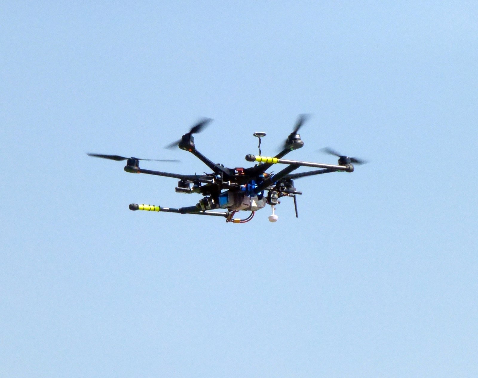
An eight-member drone team, led by the Nepali volunteer organization Hami Nepal and including personnel from GarudX, the Nepal Police, the Nepal Army, and the Armed Police Force, began flying into the Nuwakot district. Milan Pandey, a drone pilot and the director of Airlift Technology, coordinated the effort. His company assembles its aircraft in Kathmandu from imported parts. The capability that flew into Nuwakot was not donated by a foreign government or fielded by a military. A small Nepali business, a volunteer organization, and three uniformed services worked as a single eight-person team. Their primary aircraft was the DJI FlyCart 100. The whole argument turns on what that is: a large multirotor delivery drone, sold off-the-shelf for construction resupply and remote logistics rather than for disaster work. It carries up to 85 kilograms of cargo out to a range of four kilometers. Nothing about it is military, and nothing about it is scarce.
In three days, the team delivered at least 1.5 metric tons of food and medical supplies, dropping loads onto school rooftops and into villages that ground convoys could not reach. Thermal aircraft scanned riverbanks for survivors and for the missing. Drones flew into the flooded tunnel of the Upper Trishuli-1 hydropower project searching for trapped workers.
Pandey’s assessment of the economics was blunt: it is, he said, the cheapest mode of transporting supplies compared to helicopters. What he asked for afterward was not equipment but governance. He wanted, in his words, “an appropriate policy to promote such a life-saving machine.”
He is right on both counts, and the first is precisely the problem coming.
The Second-Day Problem
Cheap, capable, and available means many. Government teams, volunteer organizations, commercial operators, news media, insurers, and well-meaning individuals all converge on the same square kilometers of low airspace, and they do so with no shared plan.
The pattern is documented. In response to the 2026 Venezuela earthquake sequence and its triggered landslides, the airspace over the disaster became a mosaic of independent operations by the second day. There was no unified command, no shared airspace picture, no common frequency, and no flight-plan deconfliction. Local responders reported near-misses between drones and helicopters that were serious enough to pause missions until the sky could be cleared. Rescue aircraft held or diverted. The uncrewed traffic management system in place failed for the simplest of reasons: it assumed connectivity, and the disaster had destroyed it. The very technology that accelerated incident response had started to slow it down.
Terrain damage, communications outages, dust, smoke, and weather all compound the problem. So does the electrical grid: in Nepal, roughly 753 megawatts came offline, and border areas lost communications and power entirely. A deconfliction scheme that assumes connectivity is a deconfliction scheme that fails in exactly the conditions that generate the requirement.
Nepal appears to have avoided the worst of this, and the reason is instructive rather than reassuring. The team that flew was small and integrated, with police, army, and armed police personnel. Coordination was achieved by keeping the number of players low and putting the authorities in the same eight-person team. That works at eight. It does not scale, and the next disaster of this magnitude in a more accessible country will not have the luxury of eight.
A Common Operating Air Picture Is a Command Function
The public safety community has begun naming the requirement directly: what a disaster needs is a common operating air picture, a single, shared, authoritative view of who is flying, where, at what altitude, on whose authority, and for how long. That is not a product. The requirement is a staff function with a product attached, and the distinction matters because agencies keep trying to buy the second without building the first.
In August 2021, during the evacuation from Kabul, the J-4 I was working in became a joint logistics operations center (JLOC) almost overnight. Afghanistan’s collapse left partner nations without their own supply lines, and they turned to the US chain to sustain both their forces and the evacuees they were lifting out. The hard part was never the display. We had to settle four things in the first hours. Who made the decision on who got what? What was the reporting cycle across national contingents that had never reported through a common channel? Which organizations had to be physically represented at the table? And what did a request have to look like to be actionable, so that it could be received, deconflicted, and answered without a phone call to establish trust first?
We built that request format digitally and then discovered that some of the partners expected to use it did not have laptops to file from. The system stayed digital. What changed was who did the typing. Those partners submitted on paper, and the JLOC entered their requests into the online system on their behalf. We had a duty to support, and that duty did not wait for everyone to acquire a laptop. The structure was sound. The interface was not usable by everyone who needed it, and rather than tell those partners to solve that, the staff absorbed the gap. The technology followed the structure. It never substituted for it, and where it outran the hands that had to use it, we carried the difference ourselves.
Airspace over a disaster is the same problem in a different medium. It requires an air coordination element to be stood up on day one, with the authority to assign, not merely to observe. It requires a single reporting channel that a volunteer with a FlyCart can actually use. Not a military common operational picture that assumes a cleared network, but a low-bandwidth, phone-capable means of filing intent. And it requires an agreed altitude structure, deconflicting the uncrewed layer from rotary-wing rescue by geometry rather than by radio call, because radio calls fail when the tower is underwater.
There is at least one precedent for improvising this well. During the Canary Islands volcanic eruption, Spanish authorities deployed mobile air traffic controllers into the disaster zone, one of the earliest examples of improvised uncrewed traffic management in a response. It worked because someone treated the airspace as terrain to be controlled rather than as a medium that would sort itself out.
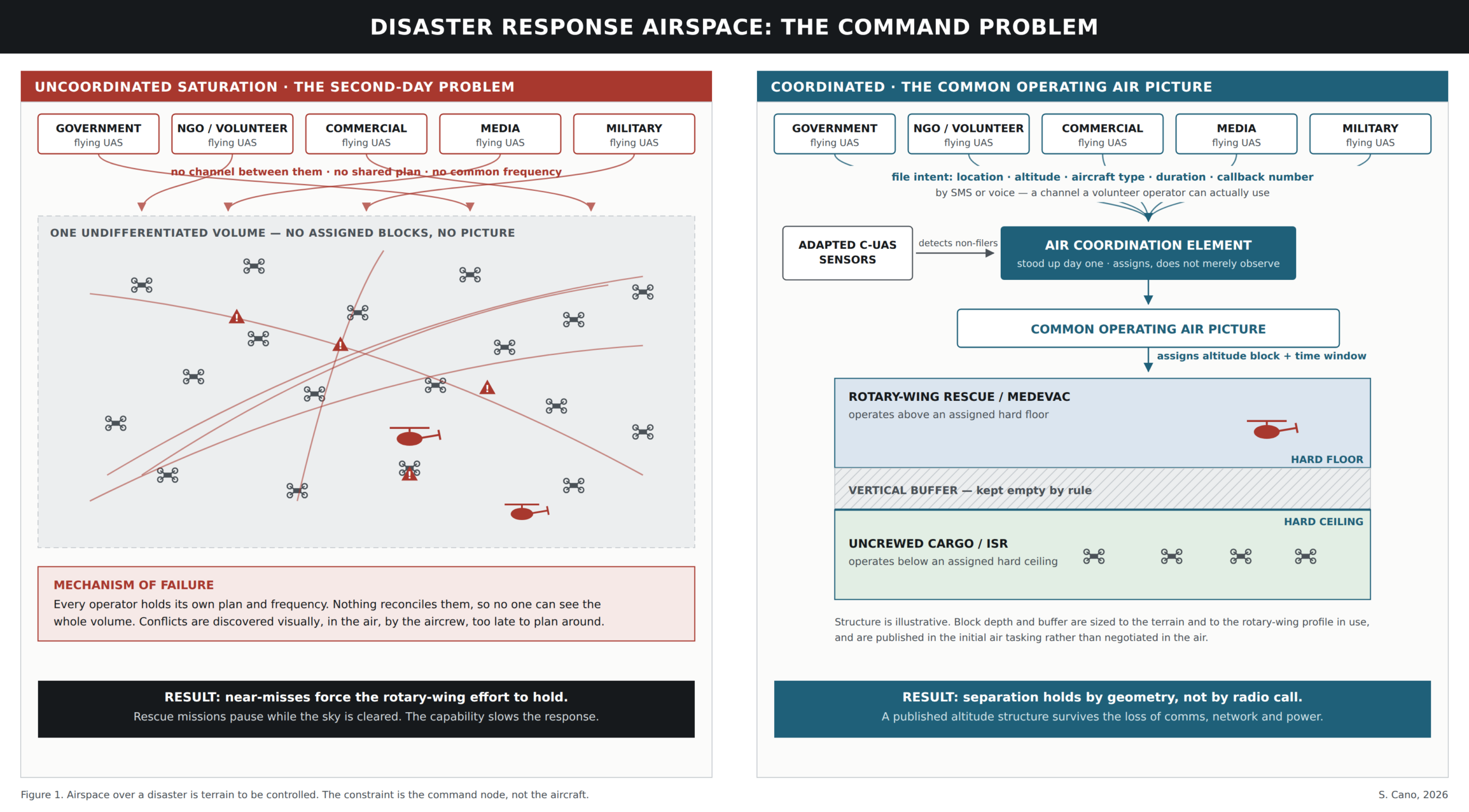
Figure 1: Airspace over a disaster is terrain to be controlled. The constraint is the command node, not the aircraft.
Borrowing from the Counter-Drone Fight
There is an irony here that the humanitarian community should exploit rather than resist.
The last decade of military and homeland security investment has gone into detecting, identifying, tracking, and characterizing uncooperative small uncrewed aircraft. Airports, stadiums, and forward bases have fielded systems that build exactly the picture a disaster response needs: a real-time inventory of every small aircraft in a given volume of airspace, correlated with an operator where possible, displayed on a single screen.
The counter-drone problem and the disaster deconfliction problem are the same sensing problem, with the intent reversed. One asks who is flying here who should not be. The other asks who is flying here, and whether they are going to hit the medevac helicopter. The sensors do not care about the difference.
Two implications follow. First, national disaster agencies should stop treating uncrewed traffic management as a capability to be developed from scratch. It is an adaptation of fielded counter-drone equipment, most of which the security services that deploy alongside them already own. Second, the military organizations that hold this equipment should plan for its humanitarian employment before they are asked, because the request will come during the response, when the staff is saturated, and the legal review has not been done.
That second point is the one that requires work now. Consequence-management authorities, status of forces considerations, and host nation frequency approvals are solvable in advance and nearly unsolvable in the first 72 hours of a catastrophe. So is the harder question underneath them.
The Objection Worth Taking Seriously
There is an obvious problem with everything above, and it deserves better than a footnote.
The sensor suite that deconflicts a medevac helicopter is the sensor suite that surveils a population. It arrives on foreign military platforms, operated by foreign military personnel, and it builds a persistent real-time picture of everything flying over sovereign territory, which in practice means a picture of what is happening on the ground beneath it. It shows up at the precise moment a host government is least able to negotiate terms, because the alternative to accepting it is watching people die. That is not a data-handling technicality. It is a question of sovereignty, and a government that refuses on those grounds is not unreasonable. Nepal’s own hesitance during this response drew scrutiny at the time. It reads better as a sovereign judgment than as an administrative failure.
The answer is not to pretend the tension away. Better to resolve it before the crisis, which is the only time it can be resolved honestly. Consequence-management annexes negotiated in advance, not improvised in hour six. Host-nation personnel inside the air coordination element with the authority to assign, not to observe. Detection and track data as the default product, with imagery held to a separate and higher threshold. A published retention and destruction standard agreed before the equipment deploys. And a defined expiry on the authority, so that a capability introduced for a flood does not quietly become a permanent one.
None of that is free, and a host nation may still say no. But the alternative to a governed air picture is not an unsurveilled sky. The same aircraft fly overhead, collecting the same imagery, with nobody accountable for any of it.
What Should Change
Four things, none of which require new technology.
Stand up an air coordination element on day one. Not day three, when saturation has already produced the first near-miss. It should be part of the initial assessment team’s manning document, with a named individual and delegated authority to assign altitude blocks and time windows.
Publish a filing standard that a volunteer can meet. If the only way to enter the system is a military or civil aviation form, the volunteers who are already flying will not use it, and the picture will be wrong in the way that matters most. A text message with location, altitude, aircraft type, duration, and a callback number is enough to deconflict, with the coordination cell transcribing it into whatever system it uses. In Kabul, we typed our partners’ paper requests into the online system for them. It cost the staff far less than the requests we would otherwise never have seen.
Deconflict by geometry first. Assign the uncrewed layer a hard ceiling and the rotary-wing rescue effort a hard floor, with a buffer, and enforce it as a standing rule rather than a negotiated one. Radios and networks will fail; a published altitude structure survives the loss of both.
Exercise it with the volunteers, not around them. The organizations that showed up in Nepal (Hami Nepal, GarudX, Airlift Technology) are the ones that will show up next time in that country and, increasingly, in others. They are a capability. A national response plan that treats them as an uncoordinated hazard will get exactly that.
Conclusion
The Nepal flood killed more than fourteen hundred people and left more than five thousand missing. The drone teams that flew into Nuwakot delivered a metric ton and a half of supplies, searched a flooded tunnel for trapped workers, and carried seven of the dead out of ground no one else could reach. That is not a technology demonstration. That capability has arrived, priced within the reach of a volunteer organization, and will be present at every significant disaster from here forward.
The constraint on that capability is no longer the aircraft. It is whether anyone is commanding the airspace they fly in. In a crisis, the advantage does not go to the responder with the most aircraft. It goes to the one who can see the whole picture and decide inside the window that still counts.
That has always been a staff problem. Better decided now, while the sky over the next disaster is still empty.
